
By Dr Safaa Sindi, Centre for Future Transport and Cities, and Dr Hossein Zarei
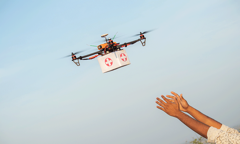
Whether it is the delivery of blood supplies urgently needed in an out-of-reach clinic or creating an aerial map following the disaster for the search and rescue operations, drones are finding their place in disaster relief.
We look at examples from recent disasters to identify the challenges and opportunities of using drones and explore whether they are becoming game changers in humanitarian aid.
Unmanned Aerial Vehicles (UAVs), commonly known as drones, have emerged as valuable tools for humanitarian relief, disaster preparedness and mitigation. Their versatility, affordability, and portability make them indispensable assets in crises. They are being increasingly utilised in relief efforts by supporting a wide range of operations from searching for bodies to scanning infrastructure vulnerability by creating footage of the aftermath. Drone testing and application work has included the delivery of vital food packages, and medical supplies, facilitating emergency response efforts, such as search and rescue, and generating aerial maps to assess damage and disease outbreaks mapping. The integration of drones into national disaster response systems has ushered in a new era of data intelligence. By harnessing aerial and satellite imagery alongside geospatial data, social media feeds, crowdsourced information, and sensor data, comprehensive disaster monitoring and analysis have become possible.
Deployment in recent crises
Drones have been used in current humanitarian relief such as the recent 2023 floods in Libya where strong winds and heavy floods caused by Storm Daniel led to two dams upstream of the coastal city of Derna collapsing. Drones were used to map images and show the extent of the destruction in the city of Derna. Drones have also been deployed for search and rescue missions and mapping the extent of the affected infrastructure for utility companies (e.g. telecommunication and electricity) to assess the level of damage. Disease outbreaks are prevalent following floods caused by contaminated water and the lack of sanitation. Water companies and civil services can adopt drone technology to assess the damage and map out disease outbreaks. Similarly, drones have been used in the recent 2023 earthquake response in Morocco to map the extent of the damage and create heat maps for search and rescue missions.
Another disaster where drones have shown to be instrumental was Cyclone Eloise in January 2021, where drones were utilised to help and search for survivors in affected parts of Mozambique, Malawi, Eswatini, Zimbabwe, and South Africa. Thus, the incorporation of drones in rescue missions has helped save numerous lives, who had little chance of surviving when the disaster struck. Another example is the use of drones for search and rescue operations and distributing humanitarian assistance during South Africa’s 2017 fire disasters that devastated the Western and Eastern Cape provinces. The emergency crews relied on drones to assess the damage and identify the hotspot areas where the fire was greatest. Drones can be utilised to generate imagery for reporting purposes. Consequently, such imagery assisted rescue missions in communicating accurate information during disasters when helping and searching for survivors.
There is still little information on the use of drones in the ongoing 2023 Israel-Gaza conflict, but in such situations where roads are inaccessible or unsafe, drones can be used by humanitarian organisations to distribute relief parcels such as food and medicine directly to communities. An example from the region is the aid effort led by Jordan to air-drop aid parcels of medicine and food.
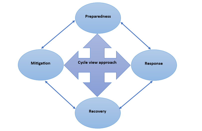
Drones from disaster cycle view
The role of drones in humanitarian and disaster relief can span four key areas presented in a disaster cycle view: mitigation, preparedness, response, and recovery.
Mitigation: This is a pre-disaster phase where potential risks are identified, and mitigation actions are taken. Drones can identify priority areas where disease might occur, determine where hotspots for aid delivery might occur, and develop aerial footage to map the integrity of infrastructure or areas prone to disasters or wildfires.
Preparedness: This phase is in anticipation of an imminent crisis and involves activities such as inventory prepositioning and preparing aid kits. Drones can be used to identify the optimum locations for setting up temporary clinics or warehouses to be used upon the onset of a disaster.
Response: This happens immediately after a disaster strikes. Drones can play a vital role in mapping hotspots for infrastructure damage, search and rescue missions, and delivering emergency aid to inaccessible areas.
Recovery: This phase involves long-term operations following the disaster to build back society and help it stand on its own feet. Drones can create satellite imagery to identify priority areas where reconstruction is needed most, image mapping of before and after can assess the integrity of infrastructure or assess the damage and deliver aid to rural areas where the recovery process is slowest.
Challenges of using drones
The adoption of drones is hindered by a variety of barriers. High utilisation costs, incompatible infrastructure for charging and operating drones, lack of skilled personnel for operations and maintenance of drones, and restrictive regulations, all of which limit the full utilisation of drone technology. These barriers have led to slower uptake of drones, especially in the least developed as well as developing countries. Ironically, these are the countries where drones are needed the most for humanitarian aid.
There are also significant concerns about the ethical use of drones, privacy, and data protection, for which we do not yet have clear answers nor suitable regulations. Drones are powerful tools, and if fallen into the wrong hands can become a significant threat to society. Cases of misusing drones by militias in armed conflicts to conduct military operations are a cause of growing concern. Finally, drones have constraints in terms of range and the weight of load they can carry, which hinders their utilisation for some aid operations.
The road ahead
Drones are coming to the forefront and are indeed a game changer for the future of humanitarian aid as they have shown immense potential in all the phases of the disaster cycle. To allow drones to reach their full potential we encourage governments to consider drone technology adoption for humanitarian aid and for mitigating impacts of disasters through enabling regulatory and infrastructural frameworks. We also need international regulations to address the ethical and security concerns related to drones.
For humanitarian organisations, it is imperative to develop programmes to train rescue services to pilot drones, combining both theoretical and practical approaches for navigating, testing, and flying drones to build local skills, and capacity and create a favourable ecosystem for sustainable models for using drones in humanitarian missions. A growing body of research is looking at the use of drones in combination with other modes of transport for humanitarian aid, i.e. road, rail, and sea, to develop multi-modal transport networks involving drones.
Looking at recent disasters and crises, drones have proven to be an ideal means of delivering humanitarian aid quickly and efficiently. The public sector, private businesses, and humanitarian organisations need to collaborate more closely to help drones reach their full potential in humanitarian aid operations.

Comments are disabled